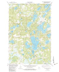
1982 Map of Birch Island Lake
USGS Topo · Published 1983About this map
Glacial geology and water define this portion of Burnett County, where the landscape is an intricate network of kettle lakes and wetlands. The 1982 survey reveals a transition from the conservation-focused Culbertson Springs State Fishery Area and the quiet waters of Des Moines Lake to the modern recreational development at the Voyager Village Country Club. The presence of the Voyager Village Landing Strip alongside Kilkare Road illustrates the mid-century evolution of the Wisconsin Northwoods into a fly-in resort destination. Local history and genealogy are centered near the Jackson Cem and the local Townhall, while the terrain remains dominated by water bodies like Birch Island Lake, Sand Lake, and the expansive Kilkare Marsh.
Find a feature on this map
57 named features on this map. Tap any name to fly to it.
Don’t see what you’re looking for? This feature index may not catch every label — zoom into the map to look around manually.
Map Details
Editions of this 1982 Birch Island Lake Map
This is the sole edition of this map. No revisions or reprints were ever made.
Other maps of this area

1949 · Danbury
USGS Topo · 1:48,000

1949 · Hertel
USGS Topo · 1:48,000

1949 · Webb Lake
USGS Topo · 1:48,000

1950 · Webster
USGS Topo · 1:48,000

1953 · Duluth
USGS Topo · 1:250,000

1953 · Stillwater
USGS Topo · 1:250,000

1955 · Hertel
USGS Topo · 1:62,500

1955 · Webb Lake
USGS Topo · 1:62,500

1955 · Webster
USGS Topo · 1:62,500

1955 · Stillwater
USGS Topo · 1:250,000