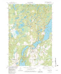
1982 Map of Birchwood
USGS Topo · Published 1982About this map
Birchwood serves as the focal point of this northern Wisconsin landscape, situated where Birch Lake and Balsam Lake converge at the borders of Washburn, Barron, and Sawyer counties. The area is defined by a dense concentration of glacial water bodies, from the sprawling waters of Spider Lake and Nice Lake to smaller basins like Eliza L and Telstar Lake. A distinctive transport corridor is formed by the Tuscobia Parkway State Trail, which cuts across the terrain south of the village, following a former rail alignment near the settlement of Angus.
Find a feature on this map
54 named features on this map. Tap any name to fly to it.
Don’t see what you’re looking for? This feature index may not catch every label — zoom into the map to look around manually.
Map Details
Editions of this 1982 Birchwood Map
This is the sole edition of this map. No revisions or reprints were ever made.
Other maps of this area

1944 · Couderay
USGS Topo · 1:48,000

1945 · Meteor
USGS Topo · 1:48,000

1948 · Couderay
USGS Topo · 1:48,000

1948 · Stone Lake
USGS Topo · 1:48,000

1949 · Meteor
USGS Topo · 1:48,000

1949 · Rice Lake
USGS Topo · 1:48,000

1950 · Stone Lake
USGS Topo · 1:48,000

1951 · Rice Lake
USGS Topo · 1:48,000

1953 · Rice Lake
USGS Topo · 1:250,000

1959 · Rice Lake
USGS Topo · 1:250,000