
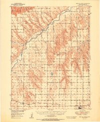
1951 Map of Bird City North
USGS Topo · Published 1951About this map
Republican River and its South Fork carve a complex network of canyons across this Cheyenne County landscape as it appeared in the early 1950s. The terrain is defined by deep, family-named draws such as Dave Harvey Canyon, Morehouse Canyon, and Pigg Canyon, reflecting the homesteading history of the High Plains. The industrial and social backbone of the region is clearly marked by the Chicago Burlington and Quincy railroad line, which connects the primary settlements of Wheeler and Bird City. A dense distribution of rural institutions highlights a once-populated agrarian society, featuring numerous schools like Riverside Sch and Plainview Sch, and local landmarks such as Horsethief Cave. Small impoundments including Cole Pond and Leach Pond dot the townships of Calhoun and Orlando, serving as vital water sources in this semi-arid prairie environment.
Find a feature on this map
43 named features on this map. Tap any name to fly to it.
Don’t see what you’re looking for? This feature index may not catch every label — zoom into the map to look around manually.
Map Details
Editions of this 1951 Bird City North Map
2 editions found
Other maps of this area

1942 · St. Francis
USGS Topo · 1:62,500

1943 · St. Francis
USGS Topo · 1:62,500

1950 · Mc Donald
USGS Topo · 1:62,500

1951 · St Francis
USGS Topo · 1:62,500

1951 · Mc Donald
USGS Topo · 1:62,500

1951 · Bird City South
USGS Topo · 1:62,500

1951 · Dewey Ranch
USGS Topo · 1:62,500

1952 · St Francis 3
USGS Topo · 1:62,500

1954 · McCook
USGS Topo · 1:250,000

1954 · Goodland
USGS Topo · 1:250,000