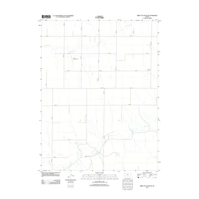
2012 Map of Bird City South SE
USGS Topo · Published 2012About this map
Little Beaver Cr and Beaver Cr meander through the high plains of northwest Kansas, defining the drainage patterns of this agricultural landscape. The map reveals a highly structured grid of section roads, including Co Line Rd and Road 79, which facilitate the region's ranching and farming operations. This 2012 survey identifies key local landmarks essential for genealogical research and community history, such as the Sunnyside Cem and Shermanville Cem. The presence of the Bursch Private Airport underscores the importance of private aviation in navigating these expansive distances. Unlike many eastern maps, the lack of concentrated town centers here highlights the dispersed nature of High Plains settlement, where life is organized around watercourses and a rigorous township-and-range survey system.
Find a feature on this map
21 named features on this map. Tap any name to fly to it.
Don’t see what you’re looking for? This feature index may not catch every label — zoom into the map to look around manually.
Map Details
Editions of this 2012 Bird City South SE Map
This is the sole edition of this map. No revisions or reprints were ever made.
Other maps of this area

1951 · Bird City South
USGS Topo · 1:62,500

1951 · Dewey Ranch
USGS Topo · 1:62,500

1954 · Goodland
USGS Topo · 1:250,000

1956 · Goodland
USGS Topo · 1:250,000

1957 · Goodland
USGS Topo · 1:250,000

1966 · Goodland NW
USGS Topo · 1:24,000

1966 · Goodland NE
USGS Topo · 1:24,000

1966 · Brewster NW
USGS Topo · 1:24,000
1981 · Bird City South NW
USGS Topo · 1:24,000
1981 · Dewey Ranch SW
USGS Topo · 1:24,000