
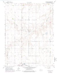
1966 Map of Goodland NW
USGS Topo · Published 1967About this map
Voltaire and Logan townships define the landscape of this high plains region, where the intermittent drainage of the Middle Fork Sappa Cr and the South Fork carve subtle valleys into the agricultural plateau. The mid-1960s survey documents a sparse rural infrastructure characterized by isolated landmarks like the Prairie Star Sch and a Gravel Pit near Beaver Creek. The southern edge of the map reveals the growth of local utility and transportation hubs, featuring a prominent Radio Tower and the Goodland Municipal Airport (Renner Field). This transition between traditional farmsteads and modern municipal footprints provides a clear view of the area's development during the mid-century period, anchored by the technical facilities of the Sewage Disposal site and the expansive runway of Renner Field.
Find a feature on this map
10 named features on this map. Tap any name to fly to it.
Don’t see what you’re looking for? This feature index may not catch every label — zoom into the map to look around manually.
Map Details
Editions of this 1966 Goodland NW Map
2 editions found
Other maps of this area

1951 · Bird City South
USGS Topo · 1:62,500

1952 · St Francis 3
USGS Topo · 1:62,500

1954 · Goodland
USGS Topo · 1:250,000

1956 · Goodland
USGS Topo · 1:250,000

1957 · Goodland
USGS Topo · 1:250,000

1966 · Goodland
USGS Topo · 1:24,000

1966 · Edson
USGS Topo · 1:24,000

1966 · Ruleton NE
USGS Topo · 1:24,000

1966 · Goodland NE
USGS Topo · 1:24,000
1966 · Ruleton SE
USGS Topo · 1:24,000