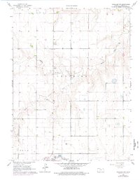
1966 Map of Goodland NW
USGS Topo · Published 1977About this map
Middle Beaver Creek and South Beaver Creek carve through the High Plains of western Kansas in this topographic study, converging into Beaver Creek as it winds through Voltaire township. The landscape is defined by the section-line roads and scattered agricultural improvements typical of the mid-1960s, a period when the rural school system was still represented by landmarks like the Prairie Star Sch. Near the southern edge, the terrain transitions into Logan township, where the headwaters of Sappa Cr appear near infrastructure like a Radio Tower and Sewage Disposal site. This map serves as a record of the drainage patterns and land use in Sherman County before late-20th-century center-pivot irrigation and consolidated farming further altered the local topography.
Find a feature on this map
10 named features on this map. Tap any name to fly to it.
Don’t see what you’re looking for? This feature index may not catch every label — zoom into the map to look around manually.
Map Details
Editions of this 1966 Goodland NW Map
2 editions found
Other maps of this area

1951 · Bird City South
USGS Topo · 1:62,500

1952 · St Francis 3
USGS Topo · 1:62,500

1954 · Goodland
USGS Topo · 1:250,000

1956 · Goodland
USGS Topo · 1:250,000

1957 · Goodland
USGS Topo · 1:250,000

1966 · Goodland NW
USGS Topo · 1:24,000

1966 · Goodland
USGS Topo · 1:24,000

1966 · Edson
USGS Topo · 1:24,000

1966 · Ruleton NE
USGS Topo · 1:24,000

1966 · Goodland NE
USGS Topo · 1:24,000