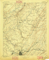
1895 Map of Birmingham
USGS Topo · Published 1901About this map
Birmingham serves as the industrial nexus of North-Central Alabama during the late 19th-century boom, a landscape defined more by its subterranean mineral wealth than its surface topography. The map reveals the intricate network of the Louisville and Nashville Railroad and the Birmingham Mineral Railroad as they thread through narrow gaps to reach critical extraction sites like Pratt Mines, Morrow Mine, and the Sloss Mine. This era’s reliance on coal and iron is anchored by landmarks such as the Old Irondale Furnace and a central Furnace near Trussville. Outside the urban center, the terrain is characterized by the Cahaba Valley and Murphrees Valley, where smaller settlements like Village Springs and Argo Station sit alongside family-run operations such as Hanby Mill and Posey Mill, illustrating the region's shift from a rural agrarian economy to an industrial powerhouse.
Find a feature on this map
160 named features on this map. Tap any name to fly to it.
Don’t see what you’re looking for? This feature index may not catch every label — zoom into the map to look around manually.
Map Details
Editions of this 1895 Birmingham Map
2 editions found

Other maps of this area

1885 · Gadsden
USGS Topo · 1:125,000

1888 · Cullman
USGS Topo · 1:125,000

1888 · Gadsden
USGS Topo · 1:125,000

1889 · Springville
USGS Topo · 1:125,000

1889 · Birmingham
USGS Topo · 1:125,000

1890 · Bessemer
USGS Topo · 1:125,000

1890 · Talladega
USGS Topo · 1:125,000

1892 · Cullman
USGS Topo · 1:125,000

1892 · Birmingham
USGS Topo · 1:125,000

1892 · Springville
USGS Topo · 1:125,000