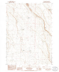
1985 Map of Biscuit Point
USGS Topo · Published 1986About this map
Brattain Waterhole No 5 and Brattain Waterhole No 7 anchor this high-desert landscape in Lake County, Oregon, where water management is the primary evidence of human activity. The map, based on a 1981 field check, reveals a sparse network of 4WD trails and vital water points essential for livestock or survival in this arid terrain. Notable landmarks like Twin Buttes and the elevation at Biscuit Point provide vertical contrast to the drainage of Sand Canyon.
Find a feature on this map
11 named features on this map. Tap any name to fly to it.
Don’t see what you’re looking for? This feature index may not catch every label — zoom into the map to look around manually.
Map Details
Editions of this 1985 Biscuit Point Map
This is the sole edition of this map. No revisions or reprints were ever made.
Other maps of this area

1955 · Klamath Falls
USGS Topo · 1:250,000

1958 · Klamath Falls
USGS Topo · 1:250,000

1966 · Coglan Buttes NE
USGS Topo · 1:24,000

1966 · Coglan Buttes
USGS Topo · 1:24,000

1968 · Lake Abert North
USGS Topo · 1:24,000

1974 · Lake Abert
USGS Topo · 1:100,000
1984 · Sawed Horn
USGS Topo · 1:24,000
1984 · Poverty Basin South
USGS Topo · 1:24,000

1985 · Sharp Top
USGS Topo · 1:24,000
1985 · Diatomite Reservoir
USGS Topo · 1:24,000