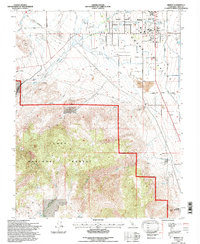
1994 Map of Bishop
USGS Topo · Published 1997About this map
The Owens Valley landscape in the mid-1990s is defined by a striking contrast between the concentrated settlement of Bishop and the expansive reach of the Inyo National Forest. This survey captures the town’s established civic infrastructure, from the Bishop High Sch and Hospital to the Tri-County Fairgrounds and the Bishop Paiute Indian Reservation. The mapping details the critical water management systems of the region, including the Owens River, various unnamed aqueducts, and the Penstock near Bishop Creek. Cultural history is preserved through the location of the Pioneer Cem and Sunland Cem, while the industrial past of the High Sierra foothills is evident in the Tungsten City Road and mining remains like the Yancy Mine. To the south, Keough Hot Springs stands as a notable landmark at the edge of the valley floor.
Find a feature on this map
35 named features on this map. Tap any name to fly to it.
Don’t see what you’re looking for? This feature index may not catch every label — zoom into the map to look around manually.
Map Details
Editions of this 1994 Bishop Map
This is the sole edition of this map. No revisions or reprints were ever made.
Other maps of this area

1912 · Mt. Goddard
USGS Topo · 1:125,000

1913 · Bishop
USGS Topo · 1:125,000

1947 · Mariposa
USGS Topo · 1:250,000

1948 · Mariposa
USGS Topo · 1:250,000

1948 · Mt. Goddard
USGS Topo · 1:62,500

1949 · Mt. Tom
USGS Topo · 1:62,500

1949 · Bishop
USGS Topo · 1:62,500

1950 · Big Pine
USGS Topo · 1:62,500

1951 · Mt. Tom
USGS Topo · 1:62,500

1951 · Mt. Goddard
USGS Topo · 1:62,500