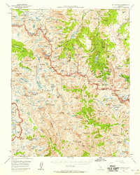
1948 Map of Mt. Goddard
USGS Topo · Published 1958About this map
Lake Sabrina and the high peaks of the Glacier Divide define this landscape on the border of the Sierra National Forest and Inyo National Forest. Published in 1958, this map captures the remote crest of the Sierra Nevada just before mid-century, documenting early alpine recreation and high-altitude mining efforts. Resource extraction is evident at the Cardinal Mine and Schober Mine, while several prospects like the Lindner Prospect indicate the geological interest of the era. The mapping of the Muir Trail as it crosses Muir Pass shows the established path for backcountry exploration through the Goddard Divide. Established outposts like Parchers Camp, Andrews Camp, and Glacier Camp provided essential bases for hikers and miners venturing into the steep canyons and glacial basins of the Kings Canyon National Park borderlands.
Find a feature on this map
197 named features on this map. Tap any name to fly to it.
Don’t see what you’re looking for? This feature index may not catch every label — zoom into the map to look around manually.
Map Details
Editions of this 1948 Mt. Goddard Map
2 editions found
Other maps of this area

1903 · Tehipite
USGS Topo · 1:125,000

1905 · Tehipite
USGS Topo · 1:125,000

1907 · Mt. Whitney
USGS Topo · 1:125,000

1912 · Mt. Goddard
USGS Topo · 1:125,000

1913 · Bishop
USGS Topo · 1:125,000

1919 · Mt. Whitney
USGS Topo · 1:125,000

1937 · Mt. Whitney
USGS Topo · 1:125,000

1947 · Mariposa
USGS Topo · 1:250,000

1948 · Fresno
USGS Topo · 1:250,000

1948 · Mariposa
USGS Topo · 1:250,000