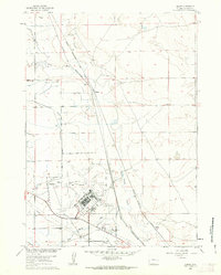
1960 Map of Bishop
USGS Topo · Published 1963About this map
Casper Air Terminal dominates the southern portion of this landscape, reflecting its mid-century role as a regional aviation hub. This 1960 revision details the extensive infrastructure supporting the airfield, including the Control Tower, a nearby Sewage Disposal plant, and the adjacent residential enclave of Air Base Acres. The surrounding high plains of Natrona County show a transition from early industrial and agricultural footprints to more modernized transit corridors.
Find a feature on this map
26 named features on this map. Tap any name to fly to it.
Don’t see what you’re looking for? This feature index may not catch every label — zoom into the map to look around manually.
Map Details
Editions of this 1960 Bishop Map
4 editions found
Other maps of this area

1950 · Emigrant Gap
USGS Topo · 1:24,000

1950 · Goose Egg
USGS Topo · 1:24,000

1950 · Emigrant Gap NE
USGS Topo · 1:24,000

1951 · The Reefs
USGS Topo · 1:24,000

1951 · Casper
USGS Topo · 1:24,000

1952 · Bishop
USGS Topo · 1:24,000

1955 · Arminto
USGS Topo · 1:250,000

1955 · Casper
USGS Topo · 1:250,000

1958 · Casper
USGS Topo · 1:250,000

1958 · Arminto
USGS Topo · 1:250,000