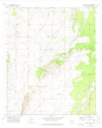
1972 Map of Bishop Ranch
USGS Topo · Published 1975About this map
Bishop Ranch serves as the focal point of this arid landscape in Socorro County, where water management defines the pattern of human activity. The terrain is deeply etched by ephemeral drainages like Arroyo Rancho and Patterson Draw, which are supported by a complex network of ranching infrastructure. Numerous catchment basins and wells, including Baumgardner Tank, Jesus Tank, and Marr Well, are dispersed throughout the hills to sustain livestock in this desert environment. Small-scale industrial attempts are visible near the southern ridges, where scattered Prospects suggest historical mineral exploration. Movement through the area is facilitated by the Chupadera Jeep Trail, connecting the high ground to the winding path of Cañon de la Rosa. This survey, field-checked in the early 1970s, captures the high-desert ranching economy before modern developments reached this part of New Mexico.
Find a feature on this map
26 named features on this map. Tap any name to fly to it.
Don’t see what you’re looking for? This feature index may not catch every label — zoom into the map to look around manually.
Map Details
Editions of this 1972 Bishop Ranch Map
This is the sole edition of this map. No revisions or reprints were ever made.
Other maps of this area

1916 · La Joya
USGS Topo · 1:125,000

1952 · Cerro Montoso
USGS Topo · 1:24,000

1954 · Socorro
USGS Topo · 1:250,000

1958 · Socorro
USGS Topo · 1:250,000

1962 · Socorro
USGS Topo · 1:250,000
1972 · Sierra Larga North
USGS Topo · 1:24,000
1972 · Chupadera Spring
USGS Topo · 1:24,000

1972 · Chupadera
USGS Topo · 1:24,000

1972 · Wilson Ranch
USGS Topo · 1:24,000
1972 · Sierra Larga South
USGS Topo · 1:24,000