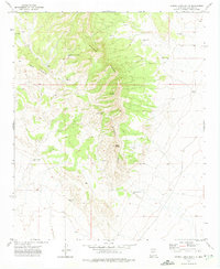
1972 Map of Sierra Larga South
USGS Topo · Published 1975About this map
Sierra Larga dominates this 1970s landscape, providing a high-relief backdrop to a scattered network of water infrastructure essential for ranching in Socorro County. The map reveals the critical importance of localized water sources, documenting a series of named points such as Tafoya Well, Turner Well, and Boulter Well along the eastern foothills. To the west, the prominent ridge of Bordo Atravesado cuts across the terrain, while landmarks like Cerro Venado and Halcomb define the interior peaks. Human activity is marked by remote outposts such as Long Ranch and Savedra Wells, alongside evidence of mineral exploration indicated by numerous prospect labels. The placement of a Radio Facility near Loma highlights the mid-century adaptation of these high-altitude positions for communication infrastructure. This survey captures a moment when the rugged interior of the San Andres Mountains area was defined by its cattle-ranching legacy and geological utility.
Find a feature on this map
18 named features on this map. Tap any name to fly to it.
Don’t see what you’re looking for? This feature index may not catch every label — zoom into the map to look around manually.
Map Details
Editions of this 1972 Sierra Larga South Map
This is the sole edition of this map. No revisions or reprints were ever made.
Other maps of this area

1916 · La Joya
USGS Topo · 1:125,000

1918 · Oscura Peak
USGS Topo · 1:125,000

1948 · Carthage
USGS Topo · 1:62,500

1948 · Bingham
USGS Topo · 1:62,500

1954 · Tularosa
USGS Topo · 1:250,000

1954 · Socorro
USGS Topo · 1:250,000

1958 · Socorro
USGS Topo · 1:250,000

1958 · Tularosa
USGS Topo · 1:250,000

1962 · Socorro
USGS Topo · 1:250,000
1972 · Sierra Larga North
USGS Topo · 1:24,000