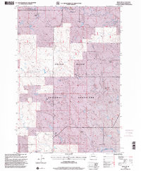
1998 Map of Bison NW
USGS Topo · Published 2001About this map
Grand River National Grassland dominates this corner of Perkins County, revealing a vast landscape defined by open range and historic family ranching operations. The map documents a series of established homesteads, including L Archibald Ranch, D Archibald Ranch, and the P Miller Ranch, illustrating the sparse but enduring settlement patterns of the South Dakota plains. Water resources are central to life here, with Lodgepole Creek and Burdick Creek threading through the northern townships while the South Fork Grand River flows along the southern boundary. Significant topographic divisions are noted through traditional names like Pleasant Valley and White Butte. The presence of the Fifth Standard Parallel North and the lone Gravel Pit further mark the intersection of formal government surveying and local industry in the late 20th century.
Find a feature on this map
25 named features on this map. Tap any name to fly to it.
Don’t see what you’re looking for? This feature index may not catch every label — zoom into the map to look around manually.
Map Details
Editions of this 1998 Bison NW Map
This is the sole edition of this map. No revisions or reprints were ever made.
Other maps of this area

1954 · Lemmon
USGS Topo · 1:250,000

1957 · Lemmon
USGS Topo · 1:250,000

1983 · Lodgepole SE
USGS Topo · 1:24,000

1983 · Haynes SE
USGS Topo · 1:24,000

1983 · Boxcar Buttes
USGS Topo · 1:24,000

1983 · Square Top Butte
USGS Topo · 1:24,000

1983 · Bison
USGS Topo · 1:24,000

1983 · Bison NE
USGS Topo · 1:24,000

1983 · Cole Dam
USGS Topo · 1:24,000

1983 · Bison NW
USGS Topo · 1:24,000