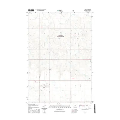
2015 Map of Bison
USGS Topo · Published 2015About this map
Bison serves as the central hub of this Perkins County landscape, situated at the intersection of White Butte Rd and Carr St. The town's layout is clearly defined by a grid of local streets including Main St, Coleman Ave, and 1st Ave W, supporting the Bison Municipal Airport and a local golf course on its outskirts. This high-plains settlement transitions into the protected acreage of the Grand River National Grassland, which dominates the northern half of the quadrangle. The topography is shaped by the drainage patterns of the South Fork Grand River and several ephemeral tributaries such as Box Spring Cr and Timber Draw Cr. Genealogists and local historians will find the Bison Cem north of town along the primary north-south corridor, providing a clear geographic anchor for family research in this rural ranching region.
Find a feature on this map
27 named features on this map. Tap any name to fly to it.
Don’t see what you’re looking for? This feature index may not catch every label — zoom into the map to look around manually.
Map Details
Editions of this 2015 Bison Map
This is the sole edition of this map. No revisions or reprints were ever made.
Other maps of this area
1954 · Lemmon
USGS Topo · 1:250,000
1957 · Lemmon
USGS Topo · 1:250,000
1983 · Boxcar Buttes
USGS Topo · 1:24,000
1983 · Square Top Butte
USGS Topo · 1:24,000
1983 · Bison
USGS Topo · 1:24,000
1983 · Bison NE
USGS Topo · 1:24,000
1983 · Cole Dam
USGS Topo · 1:24,000
1983 · Date NE
USGS Topo · 1:24,000
1983 · Owen Lake
USGS Topo · 1:24,000
1983 · Bison NW
USGS Topo · 1:24,000