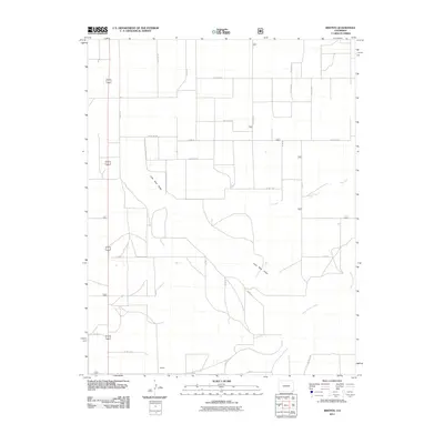
2011 Map of Bisonte
USGS Topo · Published 2011About this map
Bisonte sits in the southwestern corner of this survey, representing a remote outpost in the high plains of Baca County. The landscape is defined by the ephemeral waterways of Sand Arroyo Creek, which flows across the southeastern quadrant, and Lone Rock Draw, which cuts a path through the central portion of the quadrangle. These drainage patterns, including Dry Creek, dictate the movement of roads and the placement of rural infrastructure in this ranching territory. A rigid grid of county roads, such as Co RD Aa and Co RD 31, overlays the terrain, reflecting the modern administrative organization of the eastern Colorado grasslands. The map reveals the relationship between these sparse settlements and the wide-reaching drainage systems that characterize the local geography.
Find a feature on this map
26 named features on this map. Tap any name to fly to it.
Don’t see what you’re looking for? This feature index may not catch every label — zoom into the map to look around manually.
Map Details
Editions of this 2011 Bisonte Map
This is the sole edition of this map. No revisions or reprints were ever made.
Other maps of this area

1891 · Springfield
USGS Topo · 1:125,000

1892 · Vilas
USGS Topo · 1:125,000

1893 · Springfield
USGS Topo · 1:125,000

1955 · La Junta
USGS Topo · 1:250,000

1958 · La Junta
USGS Topo · 1:250,000

1968 · La Junta
USGS Topo · 1:250,000

1978 · Springfield SW
USGS Topo · 1:24,000

1978 · Campo NE
USGS Topo · 1:24,000
1978 · Bisonte
USGS Topo · 1:24,000
1978 · Vilas North
USGS Topo · 1:24,000