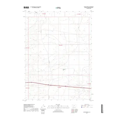
2017 Map of Bitter Creek NE
USGS Topo · Published 2017About this map
The Continental Divide traverses this high-desert portion of Sweetwater County, marking a fundamental geographic boundary in the American West. The landscape is defined by the intermittent watercourse of Tenmile Draw and a network of gravel routes, most notably Bitter Creek Rd and Co Rd 82, which navigate the various townships and ranges of the high plains. This 2017 survey reflects the modern infrastructure of the region, where Interstate 80 serves as a primary east-west artery through a terrain characterized by subtle elevation changes and expansive open space. Surveyors from the U.S. Geological Survey have meticulously mapped the grid-based township boundaries, including t20n r99w and t19n r99w, providing a clear reference for public land administration and local navigation in this isolated Wyoming environment.
Find a feature on this map
11 named features on this map. Tap any name to fly to it.
Don’t see what you’re looking for? This feature index may not catch every label — zoom into the map to look around manually.
Map Details
Editions of this 2017 Bitter Creek NE Map
This is the sole edition of this map. No revisions or reprints were ever made.
Other maps of this area

1954 · Rock Springs
USGS Topo · 1:250,000

1958 · Rock Springs
USGS Topo · 1:250,000

1958 · Twelvemile Well
USGS Topo · 1:62,500

1960 · Red Lake
USGS Topo · 1:62,500

1962 · Rock Springs
USGS Topo · 1:250,000

1968 · Bitter Creek NW
USGS Topo · 1:24,000

1968 · Bitter Creek
USGS Topo · 1:24,000

1968 · Black Buttes
USGS Topo · 1:24,000

1968 · Bitter Creek NE
USGS Topo · 1:24,000

1970 · Table Rock
USGS Topo · 1:24,000