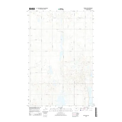
2014 Map of Bitter Lake
USGS Topo · Published 2014About this map
Bitter Lake and its surrounding wetlands dominate the interior of this prairie landscape in Nelson County, reflecting the glacial pothole geography of the region. The map documents a sparsely populated agricultural area defined by an orderly grid of section-line roads, including 109th Ave NE and 37th St NE, which facilitate movement between scattered farmsteads and fields. Significant water bodies such as Horseshoe Lake and the southern Twin Lakes punctuate the terrain, providing natural breaks in the rectangular land divisions. This 2014 survey illustrates the persistence of rural infrastructure, with routes like Co Road 15 and Cr-4 serving as primary local thoroughfares connecting the township's remote parcels.
Find a feature on this map
19 named features on this map. Tap any name to fly to it.
Don’t see what you’re looking for? This feature index may not catch every label — zoom into the map to look around manually.
Map Details
Editions of this 2014 Bitter Lake Map
This is the sole edition of this map. No revisions or reprints were ever made.
Other maps of this area

1930 · Pekin
USGS Topo · 1:62,500

1942 · McVille
USGS Topo · 1:62,500

1951 · Pekin NE
USGS Topo · 1:24,000

1951 · Pekin
USGS Topo · 1:24,000

1951 · Pekin
USGS Topo · 1:62,500

1952 · New Rockford
USGS Topo · 1:250,000

1953 · Devils Lake
USGS Topo · 1:250,000

1956 · New Rockford
USGS Topo · 1:250,000

1956 · Devils Lake
USGS Topo · 1:250,000
1961 · McVille
USGS Topo · 1:24,000