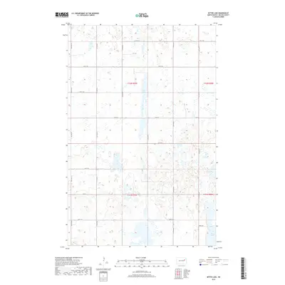
2018 Map of Bitter Lake
USGS Topo · Published 2018About this map
Bitter Lake and its surrounding wetlands dominate this prairie landscape in Nelson County, reflecting the glacial topography of the North Dakota plains. The map reveals a grid-like network of local roads such as 109th Ave NE and 35th St NE, which define the agricultural sections of t151n r59w and neighboring townships. This layout is typical of the Great Plains' Public Land Survey System, where section lines double as thoroughfares for remote farmsteads. Scattered water bodies like Horseshoe Lake and Twin Lakes suggest a variable hydrology, where seasonal changes significantly alter the shoreline and available grazing land. The presence of Orwick Dr near the southern lakes indicates small pockets of residential development or seasonal access points amidst the expansive drainage basins and fields.
Find a feature on this map
21 named features on this map. Tap any name to fly to it.
Don’t see what you’re looking for? This feature index may not catch every label — zoom into the map to look around manually.
Map Details
Editions of this 2018 Bitter Lake Map
This is the sole edition of this map. No revisions or reprints were ever made.
Other maps of this area

1930 · Pekin
USGS Topo · 1:62,500

1942 · McVille
USGS Topo · 1:62,500

1951 · Pekin NE
USGS Topo · 1:24,000

1951 · Pekin
USGS Topo · 1:24,000

1951 · Pekin
USGS Topo · 1:62,500

1952 · New Rockford
USGS Topo · 1:250,000

1953 · Devils Lake
USGS Topo · 1:250,000

1956 · New Rockford
USGS Topo · 1:250,000

1956 · Devils Lake
USGS Topo · 1:250,000
1961 · McVille
USGS Topo · 1:24,000