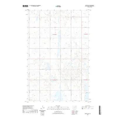
2020 Map of Bitter Lake
USGS Topo · Published 2020About this map
Bitter Lake and its surrounding wetlands dominate this pocket of the North Dakota landscape in Nelson County. The terrain is defined by numerous unnamed depressions and seasonal pools, a characteristic prairie pothole environment where the water table dictates the use of the land. Human presence is marked by a strict section-line road grid, including Co Rd 15 and Co Rd 4, which segment the landscape into traditional square-mile agricultural blocks. Towards the southeastern corner, the geography shifts toward Twin Lakes, where Orwick Dr provides access to the shoreline. This 2020 survey illustrates how modern infrastructure adapts to the variable hydrography of the region, showing how section roads like 112th Ave NE bisect larger water bodies to maintain the township and range survey system.
Find a feature on this map
20 named features on this map. Tap any name to fly to it.
Don’t see what you’re looking for? This feature index may not catch every label — zoom into the map to look around manually.
Map Details
Editions of this 2020 Bitter Lake Map
This is the sole edition of this map. No revisions or reprints were ever made.
Other maps of this area

1930 · Pekin
USGS Topo · 1:62,500

1942 · McVille
USGS Topo · 1:62,500

1951 · Pekin NE
USGS Topo · 1:24,000

1951 · Pekin
USGS Topo · 1:24,000

1951 · Pekin
USGS Topo · 1:62,500

1952 · New Rockford
USGS Topo · 1:250,000

1953 · Devils Lake
USGS Topo · 1:250,000

1956 · New Rockford
USGS Topo · 1:250,000

1956 · Devils Lake
USGS Topo · 1:250,000
1961 · McVille
USGS Topo · 1:24,000