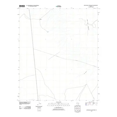
2010 Map of Bitter Well Mountain
USGS Topo · Published 2010About this map
Bitter Well Mountain dominates this high-desert landscape in Culberson County, where the terrain is defined by dry washes and sparse water infrastructure. The presence of the West Windmill and Coyote Tank illustrates the vital role of water management for ranching and livestock in this arid corner of West Texas. These scattered improvements, alongside the tracks of Roberto Rd and Stone Rd, represent the minimal human footprint on a vast, open range. The drainage of Cox Canyon carves through the southeast, providing a topographical anchor for the surrounding area. This U.S. Geological Survey 2010 edition serves as a record of the remote ranching landscape before the digital era further transformed mapping and rural land use.
Find a feature on this map
6 named features on this map. Tap any name to fly to it.
Don’t see what you’re looking for? This feature index may not catch every label — zoom into the map to look around manually.
Map Details
Editions of this 2010 Bitter Well Mountain Map
This is the sole edition of this map. No revisions or reprints were ever made.
Other maps of this area

1906 · Van Horn
USGS Topo · 1:125,000

1954 · Van Horn
USGS Topo · 1:250,000

1958 · Van Horn
USGS Topo · 1:250,000

1973 · Bitter Well Mountain NW
USGS Topo · 1:24,000

1973 · Bitter Well Mountain SW
USGS Topo · 1:24,000

1973 · Apache Peak
USGS Topo · 1:24,000

1973 · Bitter Well Mountain
USGS Topo · 1:24,000

1973 · Burro Canyon
USGS Topo · 1:24,000
1973 · Seven Heart Gap NW
USGS Topo · 1:24,000
1973 · Six Bar Ranch
USGS Topo · 1:24,000