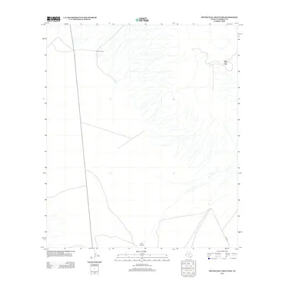
2012 Map of Bitter Well Mountain
USGS Topo · Published 2012About this map
Bitter Well Mtn stands as a prominent landmark in this desert landscape of Culberson County, marking a region defined by high-altitude plateaus and seasonal water drainage. Remote ranching infrastructure is evident at West Windmill, illustrating the practical necessities of life in the Trans-Pecos region where water management is paramount. The terrain is deeply etched by Cox Canyon, which directs the natural flow of the watershed toward the south. Access through this isolated territory is provided by Stone Rd, while Coyote Tank indicates the small-scale modifications made to the land to support livestock in an otherwise arid environment. This 2012 survey captures the persistent character of the West Texas high desert, showing how modern ranching continues to utilize traditional landmarks and water sources.
Find a feature on this map
5 named features on this map. Tap any name to fly to it.
Don’t see what you’re looking for? This feature index may not catch every label — zoom into the map to look around manually.
Map Details
Editions of this 2012 Bitter Well Mountain Map
This is the sole edition of this map. No revisions or reprints were ever made.
Other maps of this area

1906 · Van Horn
USGS Topo · 1:125,000

1954 · Van Horn
USGS Topo · 1:250,000

1958 · Van Horn
USGS Topo · 1:250,000

1973 · Bitter Well Mountain NW
USGS Topo · 1:24,000

1973 · Bitter Well Mountain SW
USGS Topo · 1:24,000

1973 · Apache Peak
USGS Topo · 1:24,000

1973 · Bitter Well Mountain
USGS Topo · 1:24,000

1973 · Burro Canyon
USGS Topo · 1:24,000
1973 · Seven Heart Gap NW
USGS Topo · 1:24,000
1973 · Six Bar Ranch
USGS Topo · 1:24,000