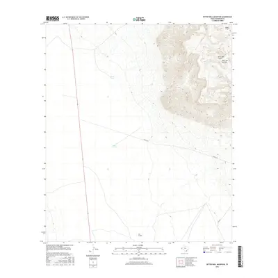
2016 Map of Bitter Well Mountain
USGS Topo · Published 2016About this map
Bitter Well Mountain rises as the central topographic feature in this arid landscape of western Texas, where the reliance on scattered water sources is evident in the naming of the land. The presence of Bitter Well Tank and Coyote Tank suggests the essential infrastructure for ranching and livestock in this environment. Steep relief is carved by several distinct drainages, including Hogue Canyon and Bitter Well Canyon in the northeast, and Cox Canyon to the south. Transportation is limited to a sparse network of unpaved routes like Roberto Rd and Stone Rd, which cut through the lower elevations and connect these isolated water and topographic landmarks. This 2016 survey illustrates the persistent ranching character of the Trans-Pecos, where named tanks and canyons serve as the primary navigational and survival points for those working the land.
Find a feature on this map
8 named features on this map. Tap any name to fly to it.
Don’t see what you’re looking for? This feature index may not catch every label — zoom into the map to look around manually.
Map Details
Editions of this 2016 Bitter Well Mountain Map
This is the sole edition of this map. No revisions or reprints were ever made.
Other maps of this area

1906 · Van Horn
USGS Topo · 1:125,000

1954 · Van Horn
USGS Topo · 1:250,000

1958 · Van Horn
USGS Topo · 1:250,000

1973 · Bitter Well Mountain NW
USGS Topo · 1:24,000

1973 · Bitter Well Mountain SW
USGS Topo · 1:24,000

1973 · Apache Peak
USGS Topo · 1:24,000

1973 · Bitter Well Mountain
USGS Topo · 1:24,000

1973 · Burro Canyon
USGS Topo · 1:24,000
1973 · Seven Heart Gap NW
USGS Topo · 1:24,000
1973 · Six Bar Ranch
USGS Topo · 1:24,000