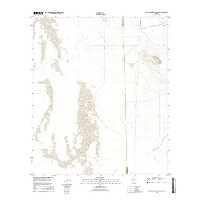
2016 Map of Bitter Well Mountain NW
USGS Topo · Published 2016About this map
The Hudspeth Co and Culberson Co boundary line bisects this remote expanse of the northern Trans-Pecos, defining a landscape of salt flats and desert basins. The terrain is characterized by the expansive white reaches of dry lake beds that dominate the western half of the map, contrasting with the rising topography toward the east. Infrastructure in this arid region remains sparse, consisting primarily of isolated desert tracks such as Chavez Rd and Guadalupe School Rd, which provide the only formal access through the basin floor. This 2016 survey illustrates the persistent isolation of the West Texas borderlands, where the political boundary between counties is one of the few prominent features across the salt-crusted flats.
Find a feature on this map
3 named features on this map. Tap any name to fly to it.
Don’t see what you’re looking for? This feature index may not catch every label — zoom into the map to look around manually.
Map Details
Editions of this 2016 Bitter Well Mountain NW Map
This is the sole edition of this map. No revisions or reprints were ever made.
Other maps of this area

1933 · Guadalupe Peak
USGS Topo · 1:48,000

1940 · Guadalupe Peak
USGS Topo · 1:62,500

1951 · Dell City
USGS Topo · 1:62,500

1954 · Van Horn
USGS Topo · 1:250,000

1955 · Black Mountains
USGS Topo · 1:62,500

1958 · Van Horn
USGS Topo · 1:250,000

1973 · Bitter Well Mountain NW
USGS Topo · 1:24,000

1973 · Bitter Well Mountain SW
USGS Topo · 1:24,000

1973 · Bitter Well Mountain
USGS Topo · 1:24,000
1973 · Patterson Hills
USGS Topo · 1:24,000