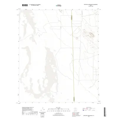
2019 Map of Bitter Well Mountain NW
USGS Topo · Published 2019About this map
The border between Hudspeth Co and Culberson Co bisects this high desert landscape, which is defined by vast open spaces and sparse infrastructure. The terrain rises to the east toward a series of prominent ridgelines, while the western portion is dominated by expansive salt flats and dry lake beds. Human presence in this arid region is marked by a few utility roads that navigate the basin floors, including Guadalupe School Rd and Chavez Rd. This late-2010s survey illustrates a landscape where the harsh physical environment has dictated a minimal pattern of settlement, leaving the topography and the county line as the most significant markers of the area's organization.
Find a feature on this map
3 named features on this map. Tap any name to fly to it.
Don’t see what you’re looking for? This feature index may not catch every label — zoom into the map to look around manually.
Map Details
Editions of this 2019 Bitter Well Mountain NW Map
This is the sole edition of this map. No revisions or reprints were ever made.
Other maps of this area

1933 · Guadalupe Peak
USGS Topo · 1:48,000

1940 · Guadalupe Peak
USGS Topo · 1:62,500

1951 · Dell City
USGS Topo · 1:62,500

1954 · Van Horn
USGS Topo · 1:250,000

1955 · Black Mountains
USGS Topo · 1:62,500

1958 · Van Horn
USGS Topo · 1:250,000

1973 · Bitter Well Mountain NW
USGS Topo · 1:24,000

1973 · Bitter Well Mountain SW
USGS Topo · 1:24,000

1973 · Bitter Well Mountain
USGS Topo · 1:24,000
1973 · Patterson Hills
USGS Topo · 1:24,000