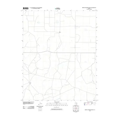
2010 Map of Bivins Channing Ranch
USGS Topo · Published 2010About this map
Bivins Channing Ranch and the nearby Bivins Channing Farm define this portion of the Texas Panhandle, where large-scale ranching and agricultural operations shape the landscape. Located in Moore County during the early 21st century, the terrain is defined by a network of intermittent watercourses that drain the High Plains, including the meandering paths of Rica Creek, East Cheyenne Creek, and Tascosa Creek. The rectilinear road system, exemplified by S County Line Rd, segments the open country into broad sections characteristic of modern Texas land management. This survey provides a clear look at the sparse but deliberate settlement pattern of the region, illustrating the essential relationship between water sources and the established agricultural holdings that occupy this semi-arid environment.
Find a feature on this map
6 named features on this map. Tap any name to fly to it.
Don’t see what you’re looking for? This feature index may not catch every label — zoom into the map to look around manually.
Map Details
Editions of this 2010 Bivins Channing Ranch Map
This is the sole edition of this map. No revisions or reprints were ever made.
Other maps of this area

1954 · Tucumcari
USGS Topo · 1:250,000

1958 · Tucumcari
USGS Topo · 1:250,000

1963 · Hartley SE
USGS Topo · 1:24,000

1963 · Bird Ranch Store
USGS Topo · 1:24,000

1963 · Stallwitz Lake
USGS Topo · 1:24,000

1971 · Bivins Channing Ranch
USGS Topo · 1:24,000

1971 · Boys Ranch West
USGS Topo · 1:24,000
1971 · Little Indian Creek
USGS Topo · 1:24,000
1971 · Boys Ranch East
USGS Topo · 1:24,000
1971 · Bautista
USGS Topo · 1:24,000