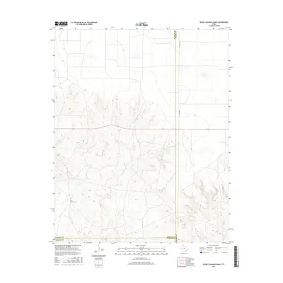
2016 Map of Bivins Channing Ranch
USGS Topo · Published 2016About this map
Bivins Channing Ranch occupies a prominent position within this stretch of the Texas Panhandle, situated at the intersection of Moore, Hartley, and Oldham counties. The landscape is defined by the drainage networks of several watercourses, including Rica Cr, E Cheyenne Cr, and Tascosa Cr, which carve through the terrain as they flow toward the Canadian River valley. The topographical data reveals a transition from the flatter high plains into the more dissected breaks, illustrating the natural erosional patterns of this ranchland region. S Co Line Rd provides one of the few formal transportation corridors across this expansive territory, following the county boundary lines that divide the survey. This 2016 production is an essential document for understanding modern land use and drainage in a region where large-scale ranching continues to shape the character of the environment.
Find a feature on this map
8 named features on this map. Tap any name to fly to it.
Don’t see what you’re looking for? This feature index may not catch every label — zoom into the map to look around manually.
Map Details
Editions of this 2016 Bivins Channing Ranch Map
This is the sole edition of this map. No revisions or reprints were ever made.
Other maps of this area

1954 · Tucumcari
USGS Topo · 1:250,000

1958 · Tucumcari
USGS Topo · 1:250,000

1963 · Hartley SE
USGS Topo · 1:24,000

1963 · Bird Ranch Store
USGS Topo · 1:24,000

1963 · Stallwitz Lake
USGS Topo · 1:24,000

1971 · Bivins Channing Ranch
USGS Topo · 1:24,000

1971 · Boys Ranch West
USGS Topo · 1:24,000
1971 · Little Indian Creek
USGS Topo · 1:24,000
1971 · Boys Ranch East
USGS Topo · 1:24,000
1971 · Bautista
USGS Topo · 1:24,000