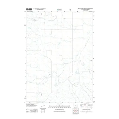
2012 Map of Black Banks Creek East
USGS Topo · Published 2012About this map
Bogner Field Airport stands as the primary aviation landmark in this northern Nebraska landscape, situated near the headwaters of several drainage systems. The terrain is defined by a dendritic network of waterways, most notably the winding course of Black Banks Cr and its northern and southern forks, N Black Banks Cr and S Black Banks Cr. These intermittent streams dictate the rural road patterns, where county highways like Co HWY 20 and Co HWY 4 intersect the prairie.
Find a feature on this map
14 named features on this map. Tap any name to fly to it.
Don’t see what you’re looking for? This feature index may not catch every label — zoom into the map to look around manually.
Map Details
Editions of this 2012 Black Banks Creek East Map
This is the sole edition of this map. No revisions or reprints were ever made.
Other maps of this area

1896 · Oelrichs
USGS Topo · 1:125,000

1900 · Oelrichs
USGS Topo · 1:125,000

1955 · Hot Springs
USGS Topo · 1:250,000

1955 · Alliance
USGS Topo · 1:250,000

1957 · Alliance
USGS Topo · 1:250,000

1958 · Alliance
USGS Topo · 1:250,000

1980 · Wolf Butte
USGS Topo · 1:24,000

1980 · Lone Tree Ranch
USGS Topo · 1:24,000

1980 · Wayside
USGS Topo · 1:24,000
1982 · Oelrichs SW
USGS Topo · 1:25,000