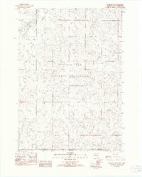
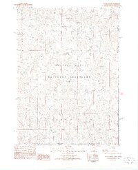
1982 Map of Oelrichs SW
USGS Topo · Published 1982About this map
Buffalo Gap National Grassland dominates this landscape along the state line in the early 1980s, revealing a vast expanse of public range land shared between South Dakota and Nebraska. The high plains terrain is defined by the prominent Slim Butte and a network of seasonal drainages including Horsehead Creek, Blacktail Creek, and Bohemian Creek. A significant piece of industrial infrastructure, the Chicago and North Western railroad, cuts through the northwestern corner of the quadrangle, following the natural corridor created by the creek valley. This provisional survey captures the intersection of Fall River County, South Dakota, and Dawes County, Nebraska, documenting the precise grassland boundaries and the sparse road network of a region where the economy was primarily tied to livestock grazing and the transport of goods by rail.
Find a feature on this map
12 named features on this map. Tap any name to fly to it.
Don’t see what you’re looking for? This feature index may not catch every label — zoom into the map to look around manually.
Map Details
Editions of this 1982 Oelrichs SW Map
This is the sole edition of this map. No revisions or reprints were ever made.
Other maps of this area

1896 · Oelrichs
USGS Topo · 1:125,000

1900 · Oelrichs
USGS Topo · 1:125,000

1955 · Hot Springs
USGS Topo · 1:250,000

1955 · Alliance
USGS Topo · 1:250,000

1957 · Alliance
USGS Topo · 1:250,000

1958 · Alliance
USGS Topo · 1:250,000

1970 · Bohemian Creek
USGS Topo · 1:24,000

1980 · Lone Tree Ranch
USGS Topo · 1:24,000

1980 · Wayside
USGS Topo · 1:24,000
1982 · Heinne Creek
USGS Topo · 1:25,000