1982 Map of Heinne Creek
USGS Topo · Published 1982About this map
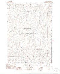
Buffalo Gap National Grassland dominates this 1982 provisional survey of the South Dakota and Nebraska borderlands. The landscape is defined by the drainage patterns of Heinne Creek, Allen Creek, and Madden Creek as they cut through the high plains. Elevation landmarks such as Slim Butte and Lone Butte provide clear navigational points across the relatively open terrain. This sheet, produced from original manuscript drawings and 1970s aerial photography, captures a specific moment in the land management of Fall River County before later modern developments. The map clearly delineates the administrative boundaries between Fall River and Shannon counties and the state line between South Dakota and Nebraska.
Find a feature on this map
9 named features on this map. Tap any name to fly to it.
Don’t see what you’re looking for? This feature index may not catch every label — zoom into the map to look around manually.
Map Details
Editions of this 1982 Heinne Creek Map
This is the sole edition of this map. No revisions or reprints were ever made.
Other maps of this area

1896 · Oelrichs
USGS Topo · 1:125,000

1900 · Oelrichs
USGS Topo · 1:125,000

1955 · Hot Springs
USGS Topo · 1:250,000

1955 · Alliance
USGS Topo · 1:250,000

1957 · Alliance
USGS Topo · 1:250,000

1958 · Alliance
USGS Topo · 1:250,000
1967 · Slim Butte SW
USGS Topo · 1:24,000

1967 · Slim Butte NW
USGS Topo · 1:24,000

1970 · Bohemian Creek
USGS Topo · 1:24,000

1970 · Isinglass Buttes
USGS Topo · 1:24,000