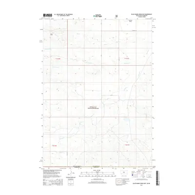
2015 Map of Black Banks Creek East
USGS Topo · Published 2015About this map
Buffalo Gap National Grassland dominates the central landscape of this 2015 survey, where the high plains of South Dakota meet the northern border of Nebraska. This region is defined by an intricate network of seasonal drainage, with Horsehead Cr meandering south toward the state line while Beef Cr and Black Banks Cr carve paths across the northern sections. The map reveals the open character of Bogner Field and the secluded Antelope Hollow, illustrating a landscape shaped by both natural erosion and large-scale public land management. Human presence is marked by a sparse grid of rural routes including Horsehead Rd and Co Hwy 20, which facilitate movement through these rangelands. The intersection of Fall River County and Dawes County highlights a cross-border topography where small waterways like Duck Cr and Fisher Cr define the subtle shifts in the high prairie terrain.
Find a feature on this map
21 named features on this map. Tap any name to fly to it.
Don’t see what you’re looking for? This feature index may not catch every label — zoom into the map to look around manually.
Map Details
Editions of this 2015 Black Banks Creek East Map
This is the sole edition of this map. No revisions or reprints were ever made.
Other maps of this area

1896 · Oelrichs
USGS Topo · 1:125,000

1900 · Oelrichs
USGS Topo · 1:125,000

1955 · Hot Springs
USGS Topo · 1:250,000

1955 · Alliance
USGS Topo · 1:250,000

1957 · Alliance
USGS Topo · 1:250,000

1958 · Alliance
USGS Topo · 1:250,000

1980 · Wolf Butte
USGS Topo · 1:24,000

1980 · Lone Tree Ranch
USGS Topo · 1:24,000

1980 · Wayside
USGS Topo · 1:24,000
1982 · Oelrichs SW
USGS Topo · 1:25,000