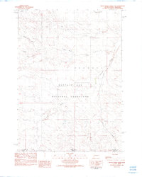
1982 Map of Black Banks Creek East
USGS Topo · Published 1982About this map
Buffalo Gap National Grassland dominates this corner of Fall River Co, revealing a landscape defined by its drainage basins and isolated ranching terrain. The map documents a complex network of waterways, including North Black Banks Creek and South Black Banks Creek, which converge as they move through the grassland towards Horsehead Creek. This 1982 provisional survey captures the area just before significant modern shifts, showing the path of the Chicago and North Western railroad as it cuts through the eastern portion of the quadrangle. Other notable landmarks like Antelope Hollow and Beef Creek illustrate the naming conventions of early settlers and ranchers in this part of South Dakota, providing a clear record of the geographic orientation of the county during the late twentieth century.
Find a feature on this map
10 named features on this map. Tap any name to fly to it.
Don’t see what you’re looking for? This feature index may not catch every label — zoom into the map to look around manually.
Map Details
Editions of this 1982 Black Banks Creek East Map
This is the sole edition of this map. No revisions or reprints were ever made.
Other maps of this area

1896 · Oelrichs
USGS Topo · 1:125,000

1900 · Oelrichs
USGS Topo · 1:125,000

1955 · Hot Springs
USGS Topo · 1:250,000

1955 · Alliance
USGS Topo · 1:250,000

1957 · Alliance
USGS Topo · 1:250,000

1958 · Alliance
USGS Topo · 1:250,000

1980 · Wolf Butte
USGS Topo · 1:24,000

1980 · Lone Tree Ranch
USGS Topo · 1:24,000

1980 · Wayside
USGS Topo · 1:24,000
1982 · Oelrichs SW
USGS Topo · 1:25,000