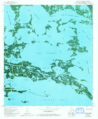
1973 Map of Black Bay North
USGS Topo · Published 1992About this map
Lake Calebasse and the surrounding marshlands of southeastern Louisiana define this 1973 orthophotomap, showing a landscape shaped by water and industry. Situated along the boundary of St. Bernard Parish and Plaquemines Parish, the region is a complex network of bays, bayous, and islands. Industrial footprints are prominent across the wetlands, with the North Black Bay Oil and Gas Field and Lake Campo Gas Field indicating the heavy extraction activity of the era.
Find a feature on this map
39 named features on this map. Tap any name to fly to it.
Don’t see what you’re looking for? This feature index may not catch every label — zoom into the map to look around manually.
Map Details
Editions of this 1973 Black Bay North Map
2 editions found
Other maps of this area

1893 · La Fortuna
USGS Topo · 1:62,500

1893 · Shell Beach
USGS Topo · 1:62,500

1893 · Dime
USGS Topo · 1:62,500

1895 · Bodreau
USGS Topo · 1:62,500

1935 · Lake Athanasio
USGS Topo · 1:31,680

1935 · Lake Calebasse
USGS Topo · 1:31,680

1939 · Shell Beach
USGS Topo · 1:62,500

1941 · Black Bay
USGS Topo · 1:62,500

1941 · Shell Beach
USGS Topo · 1:62,500
1944 · Black Bay
USGS Topo · 1:62,500