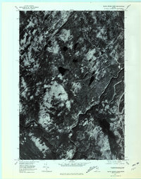
1977 Map of Black Brook Pond
USGS Topo · Published 1981About this map
The Kennebec River carves a deep, winding path through the Somerset County forest in this 1977 orthophoto survey. This specialized imagery, rectified from aerial photography, provides a literal view of the dense Maine canopy and the hydrology of the Upper Kennebec region. Dominating the southeastern quadrant is the elongated basin of Black Brook Pond, which feeds northward toward the river. To the west, the topographic prominence of Wilson Hill stands as a primary landmark in a landscape defined by dramatic relief and drainage patterns. The course of Chase Stream further illustrates the complex watershed that characterizes this section of the Maine interior, offering researchers a precise look at the land cover and water levels before more modern developments or shifts in timber management changed the forest floor.
Find a feature on this map
4 named features on this map. Tap any name to fly to it.
Don’t see what you’re looking for? This feature index may not catch every label — zoom into the map to look around manually.
Map Details
Editions of this 1977 Black Brook Pond Map
This is the sole edition of this map. No revisions or reprints were ever made.
Other maps of this area

1905 · The Forks
USGS Topo · 1:62,500

1907 · The Forks
USGS Topo · 1:62,500

1921 · Brassua Lake
USGS Topo · 1:62,500

1922 · Long Pond
USGS Topo · 1:62,500

1923 · Brassua Lake
USGS Topo · 1:62,500

1924 · Long Pond
USGS Topo · 1:62,500

1925 · Pierce Pond
USGS Topo · 1:48,000

1927 · Pierce Pond
USGS Topo · 1:62,500

1944 · Brassua Lake
USGS Topo · 1:62,500

1944 · Long Pond
USGS Topo · 1:62,500
Featured Places
- West Forks, ME
- Squaretown Township, ME
- Johnson Mountain Township, ME
- Chase Stream Township, ME
- Moxie Gore, ME