
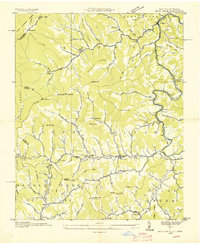
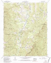
1935 Map of Black Brothers
USGS Topo · Published 1935This historical map portrays the area of Black Brothers in 1935, primarily covering Yancey County as well as portions of Buncombe County. Featuring a scale of 1:24000, this map provides a highly detailed snapshot of the terrain, roads, buildings, counties, and historical landmarks in the Black Brothers region at the time. Published in 1935, it is the sole known edition of this map.
Find a feature on this map
68 named features on this map. Tap any name to fly to it.
Don’t see what you’re looking for? This feature index may not catch every label — zoom into the map to look around manually.
Map Details
Editions of this 1935 Black Brothers Map
This is the sole edition of this map. No revisions or reprints were ever made.
Historical Maps of Murchison Through Time
10 maps found

1934 Micaville
Yancey County, NC

1934 Parts Of Celo And Black Brothers
Yancey County, NC
1935 Bald Creek
Yancey County, NC
1935 Black Brothers
Yancey County, NC
1939 Bald Creek
Yancey County, NC
1946 Mt. Mitchell
Yancey County, NC
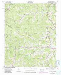
1947 Black Brothers
Yancey County, NC
1960 Celo
Yancey County, NC
1960 Micaville
Yancey County, NC
1994 Celo
Yancey County, NC