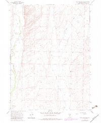
1967 Map of Black Butte SW
USGS Topo · Published 1983About this map
Marys River and Tabor Creek carve through this high desert terrain in Elko County, defining a landscape of sparse water and isolated ranching outposts. The Mala Vista Ranch stands as the primary point of human activity in the western portion of the quadrangle, accompanied by a designated Landing Area for aerial access to this remote region. The map reflects a landscape dependent on isolated water sources, marking several Springs and an individual Spring that likely served as critical watering points for livestock and wildlife alike.
Find a feature on this map
9 named features on this map. Tap any name to fly to it.
Don’t see what you’re looking for? This feature index may not catch every label — zoom into the map to look around manually.
Map Details
Editions of this 1967 Black Butte SW Map
2 editions found
Other maps of this area

1955 · Wells
USGS Topo · 1:250,000

1958 · Wells
USGS Topo · 1:250,000

1961 · Wells
USGS Topo · 1:250,000

1967 · Black Butte SW
USGS Topo · 1:24,000

1967 · Black Butte
USGS Topo · 1:24,000

1967 · Hot Springs Creek
USGS Topo · 1:24,000

1967 · Twin Buttes
USGS Topo · 1:24,000

1967 · Buena Vista Ranch
USGS Topo · 1:24,000

1967 · Black Butte NE
USGS Topo · 1:24,000

1967 · Hanks Creek NE
USGS Topo · 1:24,000