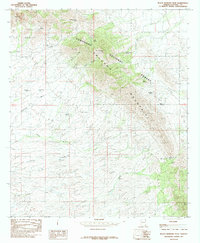
1985 Map of Black Diamond Peak
USGS Topo · Published 1985About this map
Coronado National Forest defines this high-desert landscape in Cochise County, where the southern reaches of the Dragoon Mountains create a complex network of canyons and ridges. Historically significant for its water sources and transit corridors, the area is anchored by Black Diamond Peak and the high saddles of Middlemarch Pass and South Pass. The distribution of named springs such as Black Diamond Spring, Gildo Spring, and Mace Spring reveals the essential landmarks for 1980s ranching and transit. These reliable water points are complemented by numerous livestock tanks like Gordon Tank and Round Hill Tank. Numerous Prospects scattered across the slopes indicate the persistent interest in the mineral wealth of this terrain, while ephemeral drainage systems like Haberstock Wash and Robertson Wash map the seasonal movement of water through the arid foothills.
Find a feature on this map
34 named features on this map. Tap any name to fly to it.
Don’t see what you’re looking for? This feature index may not catch every label — zoom into the map to look around manually.
Map Details
Editions of this 1985 Black Diamond Peak Map
2 editions found
Other maps of this area

1915 · Benson
USGS Topo · 1:125,000

1916 · Pearce
USGS Topo · 1:125,000

1922 · St. David
USGS Topo · 1:62,500

1925 · Gleeson
USGS Topo · 1:62,500

1926 · Courtland
USGS Topo · 1:62,500

1932 · Fairbank
USGS Topo · 1:62,500

1943 · Benson
USGS Topo · 1:125,000
1952 · Tombstone
USGS Topo · 1:24,000
1952 · Tombstone
USGS Topo · 1:62,500

1955 · Douglas
USGS Topo · 1:250,000