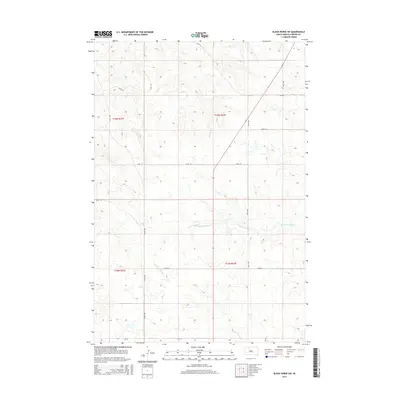
2015 Map of Black Horse SW
USGS Topo · Published 2015About this map
Standing Cloud Creek winds through the southern reaches of this landscape in Corson County, shaping the drainage patterns across the rural prairie. The terrain is defined by its Public Land Survey System divisions, including sections of t19n r21e, t19n r22e, t18n r21e, and t18n r22e. These boundaries underscore the orderly grid of the American West, where local movement relies on a network of numbered corridors such as 124th Street and 232nd Avenue. In the north, Louise Creek cuts through the topographic rises, providing one of the few named natural landmarks in this sparsely populated region. The map captures a moment in the early 21st century where the primary infrastructure consists of Bureau of Indian Affairs routes like BIA Road 4, reflecting the area's ongoing connection to tribal administration and rural land management.
Find a feature on this map
15 named features on this map. Tap any name to fly to it.
Don’t see what you’re looking for? This feature index may not catch every label — zoom into the map to look around manually.
Map Details
Editions of this 2015 Black Horse SW Map
This is the sole edition of this map. No revisions or reprints were ever made.
Other maps of this area

1953 · McIntosh
USGS Topo · 1:250,000

1956 · Black Horse NE
USGS Topo · 1:24,000

1956 · Black Horse SW
USGS Topo · 1:24,000

1956 · Cottonwood Creek NE
USGS Topo · 1:24,000

1956 · Black Horse SE
USGS Topo · 1:24,000

1956 · Black Horse
USGS Topo · 1:24,000

1956 · Cottonwood Creek SE
USGS Topo · 1:24,000

1958 · McIntosh
USGS Topo · 1:250,000

1978 · Isabel
USGS Topo · 1:24,000
1978 · Firesteel
USGS Topo · 1:24,000