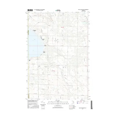
2017 Map of Black Lake Bluffs
USGS Topo · Published 2017About this map
Black Lake Bluffs rises over the northeastern shore of Black Lake, anchoring a landscape defined by the intersection of water and forest. This modern survey illustrates the shoreline communities of Canfield Beach, Rainy Beach, and Coddes Beach, showing the residential development along the lake's edge. Inland, the terrain is characterized by extensive wetlands and seasonal watercourses like Cold Cr and the Rainy River, which flow toward the larger lake system. The map reveals a transition from these low-lying marshlands to more elevated, wooded regions to the east. For local historians and genealogists, the North Allis Cem provides a specific point of interest near the southern end of the lake, while smaller bodies of water such as Lake Sixteen and Orchard Lake dot the northeastern corner. The county boundary between Cheboygan Co and Presque Isle Co runs through the western portion of the map, bisecting the lake itself.
Find a feature on this map
68 named features on this map. Tap any name to fly to it.
Don’t see what you’re looking for? This feature index may not catch every label — zoom into the map to look around manually.
Map Details
Editions of this 2017 Black Lake Bluffs Map
This is the sole edition of this map. No revisions or reprints were ever made.
Other maps of this area

1955 · Cheboygan
USGS Topo · 1:250,000

1957 · Tower
USGS Topo · 1:62,500

1957 · Cheboygan
USGS Topo · 1:62,500

1957 · Onaway
USGS Topo · 1:62,500

1958 · Cheboygan
USGS Topo · 1:250,000

1958 · Grace
USGS Topo · 1:62,500

1982 · Petoskey
USGS Topo · 1:100,000

1982 · Grace
USGS Topo · 1:24,000
1982 · Manning
USGS Topo · 1:25,000
1984 · Cheboygan
USGS Topo · 1:100,000