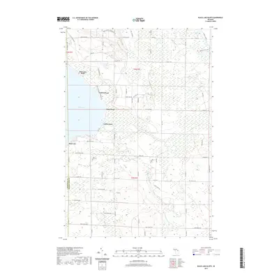
2019 Map of Black Lake Bluffs
USGS Topo · Published 2019About this map
Black Lake dominates the western edge of this landscape, its shoreline defined by a series of residential and recreational pockets. The terrain transitions from the seasonal community of Black Lake Bluffs down to Canfield Beach, Rainy Beach, and Coddes Beach. To the north, the Black Mountain Recreation Area offers a glimpse into the managed timber and recreational lands that characterize the northern Lower Peninsula. Further inland, the landscape is punctuated by the North Allis Cem and a network of named tracks like Bummers Rd and Tall Pine Trl. This region sits at the intersection of Cheboygan and Presque Isle counties, where the Rainy River and tributaries like Stony Cr drain through dense wetlands toward the larger lake basin.
Find a feature on this map
56 named features on this map. Tap any name to fly to it.
Don’t see what you’re looking for? This feature index may not catch every label — zoom into the map to look around manually.
Map Details
Editions of this 2019 Black Lake Bluffs Map
This is the sole edition of this map. No revisions or reprints were ever made.
Other maps of this area

1955 · Cheboygan
USGS Topo · 1:250,000

1957 · Tower
USGS Topo · 1:62,500

1957 · Cheboygan
USGS Topo · 1:62,500

1957 · Onaway
USGS Topo · 1:62,500

1958 · Cheboygan
USGS Topo · 1:250,000

1958 · Grace
USGS Topo · 1:62,500

1982 · Petoskey
USGS Topo · 1:100,000

1982 · Grace
USGS Topo · 1:24,000
1982 · Manning
USGS Topo · 1:25,000
1984 · Cheboygan
USGS Topo · 1:100,000