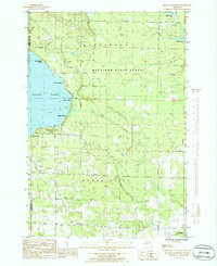
1986 Map of Black Lake Bluffs
USGS Topo · Published 1986About this map
The southeastern shores of Black Lake dominate this landscape, where the elevation rises sharply toward the Black Lake Bluffs. This 1980s-era survey reveals a coastline characterized by recreational and conservation land use, with Onaway State Park and several local landing sites such as Canfield Beach, Rainy Beach, and Coddes Beach providing access to the water. Inland, the vast Mackinaw State Forest covers much of the eastern terrain, intersected by a network of drainage systems including Cold Creek and the Rainy River.
Find a feature on this map
30 named features on this map. Tap any name to fly to it.
Don’t see what you’re looking for? This feature index may not catch every label — zoom into the map to look around manually.
Map Details
Editions of this 1986 Black Lake Bluffs Map
This is the sole edition of this map. No revisions or reprints were ever made.
Other maps of this area

1955 · Cheboygan
USGS Topo · 1:250,000

1957 · Tower
USGS Topo · 1:62,500

1957 · Cheboygan
USGS Topo · 1:62,500

1957 · Onaway
USGS Topo · 1:62,500

1958 · Cheboygan
USGS Topo · 1:250,000

1958 · Grace
USGS Topo · 1:62,500

1982 · Petoskey
USGS Topo · 1:100,000

1982 · Grace
USGS Topo · 1:24,000
1982 · Manning
USGS Topo · 1:25,000
1984 · Cheboygan
USGS Topo · 1:100,000
Featured Places
- Ocqueoc Township, MI
- Canfield Beach, MI
- Grant Township, MI
- Bearinger Township, MI
- North Allis Township, MI