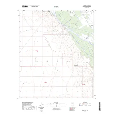
2023 Map of Black Mesa
USGS Topo · Published 2023About this map
The Rio Grande serves as the central artery for this section of the Mesilla Valley, where an intricate network of irrigation and drainage infrastructure has shaped the agrarian landscape for generations. This modern survey illustrates how water management remains vital to the region, featuring a complex system of channels such as the California Lateral, Louisiana Lateral, and the Santo Tomas Lateral. These man-made waterways contrast sharply with the arid, elevated terrain of Black Mesa and Santo Tomas Mtn to the west. On the valley floor, the established settlements of Mesilla and San Pablo are interconnected by a dense grid of local roads, including Snow Rd and River Levee Rd. The map provides a detailed record of land use in Doña Ana County, showing the transition from the fertile river bottom to the high desert plateaus of the West Mesa.
Find a feature on this map
42 named features on this map. Tap any name to fly to it.
Don’t see what you’re looking for? This feature index may not catch every label — zoom into the map to look around manually.
Map Details
Editions of this 2023 Black Mesa Map
This is the sole edition of this map. No revisions or reprints were ever made.
Other maps of this area

1891 · Las Cruces
USGS Topo · 1:125,000

1893 · Las Cruces
USGS Topo · 1:125,000

1941 · Las Cruces
USGS Topo · 1:62,500

1941 · Organ Peak
USGS Topo · 1:62,500

1943 · La Mesa
USGS Topo · 1:62,500

1943 · Organ Peak
USGS Topo · 1:62,500

1943 · Afton
USGS Topo · 1:62,500

1943 · Las Cruces
USGS Topo · 1:62,500
1955 · Tortugas Mountain
USGS Topo · 1:24,000
1955 · San Miguel
USGS Topo · 1:24,000