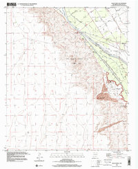
1996 Map of Black Mesa
USGS Topo · Published 2001About this map
The Mesilla Valley is defined here by an intricate network of irrigation and drainage infrastructure flanking the Rio Grande. This landscape reflects a complex history of land tenure and water management, illustrated by the presence of large colonial land grants such as Mesilla Civil Colony Tract No 1 and two tracts of the Santo Tomas De Yturbide Colony. These administrative divisions stand in contrast to the natural geological features of the east, where Black Mesa and Santo Tomas Mountain rise above the river plain, the latter showing evidence of lava flows.
Find a feature on this map
36 named features on this map. Tap any name to fly to it.
Don’t see what you’re looking for? This feature index may not catch every label — zoom into the map to look around manually.
Map Details
Editions of this 1996 Black Mesa Map
This is the sole edition of this map. No revisions or reprints were ever made.
Other maps of this area

1891 · Las Cruces
USGS Topo · 1:125,000

1893 · Las Cruces
USGS Topo · 1:125,000

1941 · Las Cruces
USGS Topo · 1:62,500

1941 · Organ Peak
USGS Topo · 1:62,500

1943 · La Mesa
USGS Topo · 1:62,500

1943 · Organ Peak
USGS Topo · 1:62,500

1943 · Afton
USGS Topo · 1:62,500

1943 · Las Cruces
USGS Topo · 1:62,500
1955 · Tortugas Mountain
USGS Topo · 1:24,000
1955 · San Miguel
USGS Topo · 1:24,000