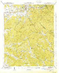
1943 Map of Black Mountain
USGS Topo · Published 1943About this map
Black Mountain and the surrounding high country of the Blue Ridge Mountains are documented here during the early 1940s, a period of established institutional presence in the region. The map highlights significant religious and social centers including the Blue Ridge YMCA Camp, the Mountain Orphanage, and several congregational sites like Tabernacle Ch and Curteys Chapel. This landscape is deeply defined by its geography, where the eastern continental divide separates the headwaters of the Catawba River and the Broad River from the Swannanoa River basin.
Find a feature on this map
103 named features on this map. Tap any name to fly to it.
Don’t see what you’re looking for? This feature index may not catch every label — zoom into the map to look around manually.
Map Details
Editions of this 1943 Black Mountain Map
This is the sole edition of this map. No revisions or reprints were ever made.
Other maps of this area

1900 · Mount Mitchell
USGS Topo · 1:125,000

1902 · Mount Mitchell
USGS Topo · 1:125,000

1907 · Saluda
USGS Topo · 1:125,000

1934 · Parts Of Old Fort and Montreat
USGS Topo · 1:24,000

1935 · Montreat
USGS Topo · 1:24,000

1935 · Batcave
USGS Topo · 1:24,000

1935 · Black Mountain
USGS Topo · 1:24,000

1935 · Craggy Pinnacle
USGS Topo · 1:24,000

1936 · Fruitland
USGS Topo · 1:24,000

1941 · Black Mountain
USGS Topo · 1:24,000