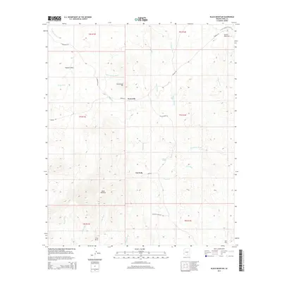
2014 Map of Black Mountain
USGS Topo · Published 2014About this map
Barkerville and Oak Wells anchor this portion of the Arizona desert, where the terrain is defined by a dense network of seasonal drainages. Significant elevation changes are marked by the Tortilla Mountains in the northeast and the prominent peak of Black Mountain in the southwest. A legacy of cattle ranching and remote settlement is evident in the presence of Double Tanks and the scattered outposts of Star Flat and Jerky Butte. The Arizona National Scenic Trail winds through the high ground, providing a rare continuous path through this landscape of deep washes like Bloodsucker Wash and Putnam Wash. The road network, including N Barkerville Rd and Freeman Rd, follows the natural contours of Haystack Valley, illustrating the sparse but deliberate human footprint in this arid environment.
Find a feature on this map
32 named features on this map. Tap any name to fly to it.
Don’t see what you’re looking for? This feature index may not catch every label — zoom into the map to look around manually.
Map Details
Editions of this 2014 Black Mountain Map
This is the sole edition of this map. No revisions or reprints were ever made.
Other maps of this area

1911 · Winkelman
USGS Topo · 1:125,000

1913 · Winkelman
USGS Topo · 1:125,000

1934 · Newman Peak
USGS Topo · 1:125,000

1949 · Crozier Peak
USGS Topo · 1:24,000

1949 · Winkelman
USGS Topo · 1:24,000

1949 · Winkelman
USGS Topo · 1:62,500

1949 · Black Mountain
USGS Topo · 1:24,000
1949 · Putnam Wash
USGS Topo · 1:24,000
1950 · Crozier Peak
USGS Topo · 1:24,000
1950 · Putnam Wash
USGS Topo · 1:24,000