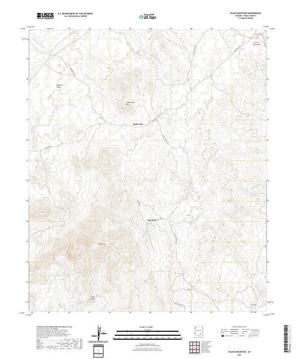
2021 Map of Black Mountain
USGS Topo · Published 2021About this map
Barkerville and Oak Wells sit within a landscape defined by an intricate network of drainage systems in Pinal County. The topography is dominated by the Tortilla Mountains in the northeast and the prominent height of Black Mtn to the south. This modern survey illustrates how traditional ranching and naming conventions persist through labels like Double Tanks and Star Flat. The drainage patterns, ranging from the widely branching Cottonwood Wash to the uniquely named Bloodsucker Wash, dictate the historical and modern movement through this arid region. For those tracking outdoor recreation and modern land use, the Arizona National Scenic Trl cuts across the northeastern corner, while local routes like Willow Springs Rd and N Barkerville Rd provide the primary access to these remote desert settlements.
Find a feature on this map
36 named features on this map. Tap any name to fly to it.
Don’t see what you’re looking for? This feature index may not catch every label — zoom into the map to look around manually.
Map Details
Editions of this 2021 Black Mountain Map
This is the sole edition of this map. No revisions or reprints were ever made.
Other maps of this area

1911 · Winkelman
USGS Topo · 1:125,000

1913 · Winkelman
USGS Topo · 1:125,000

1934 · Newman Peak
USGS Topo · 1:125,000

1949 · Crozier Peak
USGS Topo · 1:24,000

1949 · Winkelman
USGS Topo · 1:24,000

1949 · Winkelman
USGS Topo · 1:62,500

1949 · Black Mountain
USGS Topo · 1:24,000
1949 · Putnam Wash
USGS Topo · 1:24,000
1950 · Crozier Peak
USGS Topo · 1:24,000
1950 · Putnam Wash
USGS Topo · 1:24,000