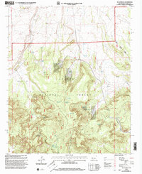
1999 Map of Black Peak
USGS Topo · Published 2002About this map
Apache National Forest lands dominate this high-altitude landscape in Catron County, where the topography centers on the namesake Black Peak. The terrain is defined by a series of significant drainage systems and geological features, including the West Fork Centerfire Creek and the long descent of Hardcastle Canyon. Water management is the primary evidence of human activity throughout this region, indicated by a dense network of tanks and springs such as White Bluff Spring, Dripping Spring, and Mullen Tank. The settlement at Renfro and the open expanse of Mangitas Flat provide specific points of interest for those tracking historical land use. This survey captures a moment when the Quemado Luna Ranger District was managing the intersection of natural resources and high-desert range, where isolated landmarks like Hardcastle Gap and Johnson Basin served as critical navigational waypoints.
Find a feature on this map
37 named features on this map. Tap any name to fly to it.
Don’t see what you’re looking for? This feature index may not catch every label — zoom into the map to look around manually.
Map Details
Editions of this 1999 Black Peak Map
This is the sole edition of this map. No revisions or reprints were ever made.
Other maps of this area

1915 · Reserve
USGS Topo · 1:125,000

1918 · Reserve
USGS Topo · 1:125,000

1954 · Clifton
USGS Topo · 1:250,000

1954 · Saint Johns
USGS Topo · 1:250,000

1955 · Red Hill
USGS Topo · 1:24,000

1957 · Clifton
USGS Topo · 1:250,000

1957 · Saint Johns
USGS Topo · 1:250,000

1958 · Clifton
USGS Topo · 1:250,000

1958 · Saint Johns
USGS Topo · 1:250,000

1962 · Clifton
USGS Topo · 1:250,000