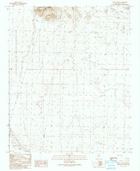
1990 Map of Black Peak
USGS Topo · Published 1990About this map
Black Peak rises as the dominant landmark in this arid landscape, a prominent summit anchoring the northern edge of the terrain. The eastern reaches of the Colorado River Indian Reservation dominate the western half of the map, illustrating the intersection of tribal lands with the open desert of Arizona’s La Paz County. Two significant drainage systems, Osborne Wash to the north and Bouse Wash to the south, define the hydrological patterns of the area, though they remain seasonally dry. Modern infrastructure is evident through the presence of a large-scale transmission line and an aboveground pipeline that traverse the desert floor, alongside Radio Facilities situated near the peak. The inclusion of a lone Well suggests the critical importance of water access for ranching or surveying in this isolated desert environment during the late twentieth century.
Find a feature on this map
10 named features on this map. Tap any name to fly to it.
Don’t see what you’re looking for? This feature index may not catch every label — zoom into the map to look around manually.
Map Details
Editions of this 1990 Black Peak Map
This is the sole edition of this map. No revisions or reprints were ever made.
Other maps of this area

1911 · Parker
USGS Topo · 1:125,000

1930 · Linskey
USGS Topo · 1:62,500

1931 · Moon Mtn
USGS Topo · 1:62,500

1932 · Moon Mtn
USGS Topo · 1:62,500

1942 · Blythe
USGS Topo · 1:250,000

1942 · MOON MTN
USGS Topo · 1:62,500

1943 · Parker
USGS Topo · 1:62,500

1949 · Parker
USGS Topo · 1:62,500

1950 · Parker
USGS Topo · 1:62,500

1954 · Salton Sea
USGS Topo · 1:250,000