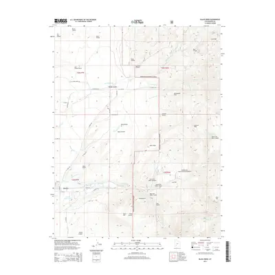
2014 Map of Black Ridge
USGS Topo · Published 2014About this map
Beaver sits at the southwestern edge of this landscape, where the Beaver River and a complex network of man-made irrigation channels supported early 21st-century agriculture in this arid Utah valley. The map documents a sophisticated water management system including the Mammoth Canal, Last Chance Canal, and several family-named or municipal waterways such as Willis Ditch and City Ditch Beaver River. These diversions draw from the high country of the Fishlake National Forest to the east, which dominates the topography with significant elevations like Rattlesnake Peak and Johnson Peak.
Find a feature on this map
67 named features on this map. Tap any name to fly to it.
Don’t see what you’re looking for? This feature index may not catch every label — zoom into the map to look around manually.
Map Details
Editions of this 2014 Black Ridge Map
This is the sole edition of this map. No revisions or reprints were ever made.
Other maps of this area

1885 · Beaver
USGS Topo · 1:250,000

1937 · Delano Peak
USGS Topo · 1:48,000

1943 · Delano Peak
USGS Topo · 1:62,500

1953 · Richfield
USGS Topo · 1:250,000

1954 · Beaver SE
USGS Topo · 1:24,000

1954 · Beaver NE
USGS Topo · 1:24,000

1958 · Richfield
USGS Topo · 1:250,000

1958 · Beaver
USGS Topo · 1:62,500
1971 · Kane Canyon
USGS Topo · 1:24,000
1971 · Greenville Bench
USGS Topo · 1:24,000