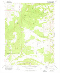
1971 Map of Kane Canyon
USGS Topo · Published 1975About this map
Coxs Ranch sits as a central human landmark in this high-desert landscape, located near a Gaging Station along the drainages of Big Twist Creek. The map documents a rugged transition in terrain, dominated by the Hurricane Cliffs and the elevated expanse of Coyote Bench. The presence of the Old Military Reservation Boundary cutting across the northern canyons suggests the area's legacy of restricted land use and surveying. Water sources are critical points of interest in this arid environment, marked by named sites like Lees Spring, Kane Spring, and Sand Cliff Spring. Navigation through the deep incisions of Kane Canyon Creek and Scrabble Canyon is depicted via numerous jeep and pack trails, reflecting the area's history of ranching and remote land management within the Fishlake National Forest.
Find a feature on this map
43 named features on this map. Tap any name to fly to it.
Don’t see what you’re looking for? This feature index may not catch every label — zoom into the map to look around manually.
Map Details
Editions of this 1971 Kane Canyon Map
This is the sole edition of this map. No revisions or reprints were ever made.
Other maps of this area

1885 · Beaver
USGS Topo · 1:250,000

1937 · Delano Peak
USGS Topo · 1:48,000

1943 · Delano Peak
USGS Topo · 1:62,500

1953 · Richfield
USGS Topo · 1:250,000

1954 · Beaver SE
USGS Topo · 1:24,000

1958 · Richfield
USGS Topo · 1:250,000

1958 · Beaver
USGS Topo · 1:62,500

1966 · Fremont Pass
USGS Topo · 1:24,000

1971 · Buckhorn Flat
USGS Topo · 1:24,000
1971 · Burnt Peak
USGS Topo · 1:24,000